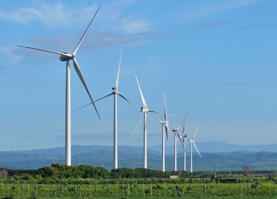
Los Cocos Wind Farm generates enough energy to keep a million bulbs lit. The one-hour informative tour is the last tourist attraction in the region and provides information on how the wind farm works. Taking advantage of the wind farm, the local community creates souvenirs with wind farm motifs, including wood models of the windmill.

Length: 900 meters. Length to the coffee farms is about 15 to 20 kms
Levels of difficulty: Low (zero)
Coordinates: Polo (18 ° 05'N - 71 ° 17'W)
Entrance to the path (18 ° 05 'N - 71 ° 17' W) Warehouse (18 ° 05 'N - 71 ° 17' W)
Altitude: Trail at 719 meters above sea level. and other areas at 950 meters above sea level
Travel time: 1 or 2 hours
Active: It has a bilingual interpretative route within the coffee factory to make possible the knowledge of the
processes from sowing until the roasting and packaging of the coffee

Longitude: 3 Kms., On the route from parking lots to first waterfall
Levels of difficulty: Low (zero)
Coordinates: (18 ° 04'N - 71 ° 06'W)
Altitude: The altitude varies from 37msnm to 781msnm
Travel time: 1.5 to 2 hours
Active: The water resource, enter a primary forest that generates unique sensory experience through its spas, streams and thick
vegetation; presence of native and endemic species of fauna and flora; allows contact with the community and
neighboring towns.
Longitude: 5 Kms
Levels of difficulty: Low (zero)
Coordinates: (18 ° 05 '06.11 N - 71 ° 13' 38.32 W)
Altitude: 873 meters above sea level. (between 700 masl and 1300 masl on the farm)
Travel time: By vehicle 45 minutes from Polo to the farm. Within the farm, 20 minutes walking.
With a bike it's 2 hours from Polo to the farm
Attractions: El Sendero and its surroundings offer the option of visiting plantations of coffee and banana in production, and approaches with
their communities in the coffee farms "La Lanza" and "Finca de Café Los Lirios"
Polo is a municipality known for its high mountains and the production of organic coffee. Each year, Polo is the headquarters of Festicafé, an organic coffee festival that promotes the preservation of the environment and the production of coffee. Visitors also come to know the nature of the area, which surprises visitors with its optical illusion, Magnetic Pole, an unusual phenomenon in which bottles and cars roll uphill instead of down. Drive to the end of the hill where the road begins to tilt, put the car in neutral and the vehicle will begin to roll backwards, apparently uphill. One of only 29 of these known "gravity hills" exist on the planet.

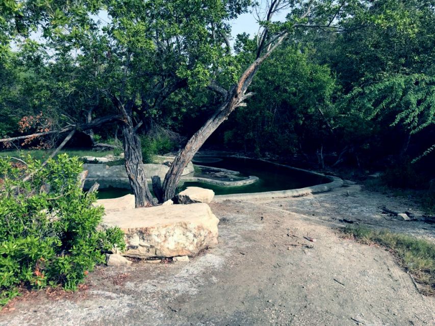
On the grounds of Villa Miriam we can find a private residence, a series of pools fed by the San Rafael River traverse the property, sprouting from the lush hills of the area. These natural pools are open to the public for a small entrance fee, and it is the perfect place for a romantic or family getaway, away from the beach and the intense heat. You can check with your hotel to arrange a visit to the residence and its outdoor facilities.
The thermal waters at Canoa are one of the most abundant, hottest and probably most medicinal. As for the benefits for the body, a bath in the thermal waters increases the temperature of the body killing germs, including viruses, also increases the hydrostatic pressure of the body, which increases blood circulation and oxygenation. This increase in temperature helps dissolve and eliminate toxins from the body.
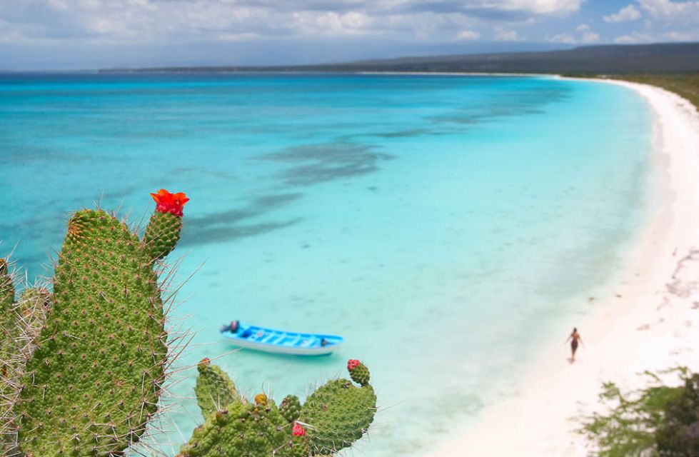
Its beaches are so beautiful and its waters so crystalline that they astonish its visitors. It is a jealously protected area since it belongs to the Jaragua National Park. In this attraction, it has not yet been approved to build tourist facilities, so we will find a totally virgin and uncontaminated area full of marine fauna and coastal flora. This place constitutes the main ecosystem of protected low energy beach within the Park. Bahía de Las Águilas was declared a World Biosphere Reserve by the United Nations Educational, Scientific and Cultural Organization (UNESCO) and the government received the certificate that accredits this area as of global ecological importance.

This iconic cave is located along the cliffs, north of Enriquillo Lake, the entrance stairway is just off the main road. After climbing a series of wooden steps, you will reach a wooden platform located directly in front of the open chambers. Explore the large number of petroglyphs through the walls, faces that suggest the presence of Tainos thousands of years ago. When leaving, take a few minutes to enjoy the panoramic view from the platform towards the road and the lagoon.

In the center of the “Malecón de Barahona”, there is the María Montez Litoral Park. The park offers the inhabitants of the area a healthy family recreation, since it has a picnic area, a skateboard and bicycle track, an amphitheater where attractive shows are held, as well as swings and games for children; gazebos in which food and craft products of the area are offered, parking spaces and maps of the area to guide visitors. It is a quality public space, which allows residents and tourists to have a space for the celebration of parades, festivities, carnivals, among other activities.

La Ciénaga is the first municipality in the province of Barahona in the coastal area, on the way to Pedernales, and it is surrounded by mountains. The vegetation corresponds to a humid tropical and subtropical forest in the highest areas. The imposing mountains that kneel in front of the sea are home to endemic flora and fauna, virgin forests and communities that live in harmony with nature. In the mountainous area, coffee and its associated fruits (mango, guava, orange, caimitos, etc.) and short-cycle products are grown.

The Larimar Wind Farm, located in Loma Buena Vista, in Enriquillo, Barahona, is the third EGE Haina wind farm. The Larimar Wind Farm has an annual production capacity of 200,000 MWh of clean energy. It will prevent the emission into the atmosphere of 140,000 tons of CO2 each year and save the annual import of 335,000 barrels of oil. This plant doubles the wind production capacity of the Dominican Republic.
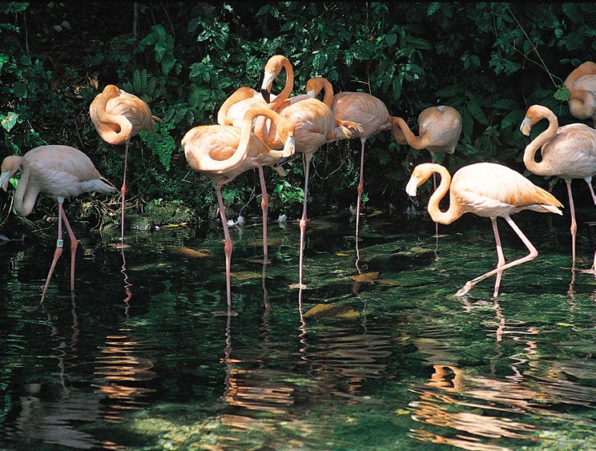
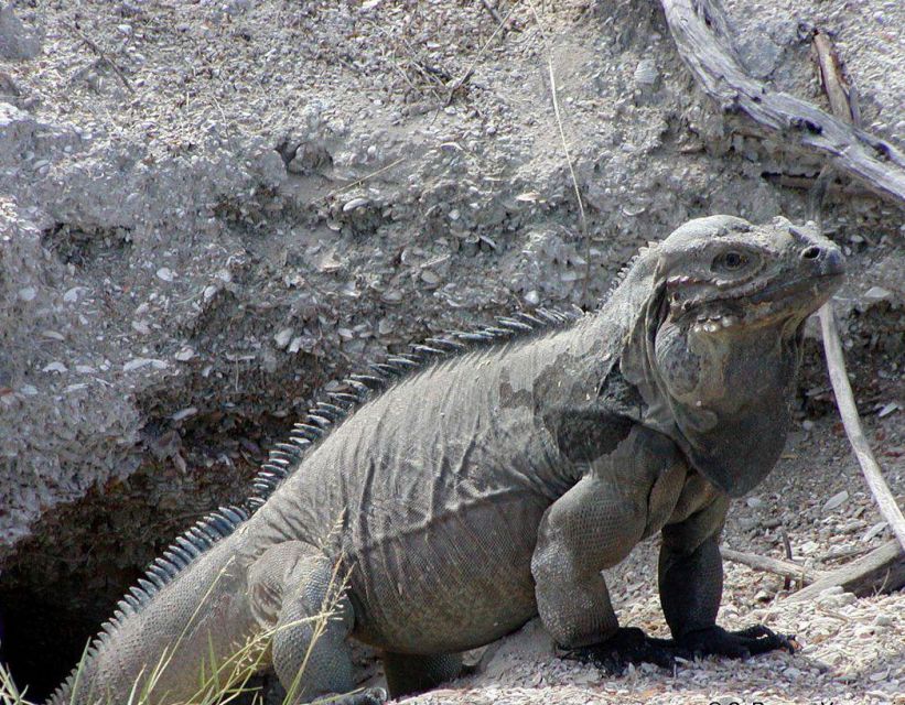
The saltwater lake, located in the Jaragua National Park, is one of the most important ecological reserves in the Caribbean and is the second largest body of water in the Dominican Republic after Lake Enriquillo. There are mangroves and 24 cays in the center of the lagoon, which visitors can see during a three-hour boat tour. Here, the colonies of Iguanas Ricordi and Rhinoceros live and nest migratory and endemic birds, which include the gray heron and the blue heron, gulls, spatula pelicans, parrots and flamingos.
It presents a beautiful and exuberant landscape with the Sierra de Neiba and the Sierra de Bahoruco, which exceed 2,000 meters above sea level. All the coasts of Isla Cabritos end in beaches, where there are no reef remains. Its soils are formed by marine lacustrine deposits, basically waterproof calcareous clays. The fauna of Isla Cabritos is represented mainly by birds and reptiles.

This protected natural area represents one of the geographical zones with the greatest diversity of ecological environments and gradients in the country, due to very complex elements that combine from a few meters above sea level to higher altitudes, which determines climatic variations that are reflected in the wide range of plant formations, starting with the dry forest at sea level, up to the humid forest in the high part of the Sierra. From 1,800 meters, the predominant vegetation is of conifers that develop on a limestone substrate. The combination of all these aspects determines a high endemism of the fauna and flora of this National Park.

Primary forest that generates unique sensorial experience crossing its spas, streams and thick vegetation; presence of native and endemic species of fauna and flora; and allows contact with the community and nearby towns. The environment with a thick virgin vegetation, trees of immense roots that exceed the twenty meters of height, vines that entangle in the immense trunks like reptiles of past epochs, numerous springs and presence of hydric resources whose journey culminates when arriving at a canyon of Huge stones with a waterfall known as Hell's Throat is unique and original.

It is located among mangroves, in the community of Juancho, Southwest to Punta Regalado, South to El Cajuil and Northeast to Punta Arena. Cayo Pisaje has an altitude of 9 meters. A natural beauty surrounded by crystalline waters and with the Cocos Wind Farm in the background. It offers a unique experience with the fishermen of the area, who are the ones who make the journey to know the attractiveness.

The Larimar mines in Bahoruco are a popular destination for adventurers and the only place in the world where Larimar can be found. Local miners spend eight to nine hours a day mining this rare semiprecious blue stone 700 feet (213 meters) deep in the mountains. Visitors can explore the mines with local tour operators or visit local workshops where they can select a Larimar piece and witness the cutting and polishing process.

Located one hour from Paradise in the Sierra de Bahoruco National Park, this village, on the top of a hill and its winding trails, offers a great ecotourism attraction. Visitors can observe a variety of tropical flora, including bromeliads and wild orchids. Since it is located at a higher altitude in a cloud forest, it is also a paradise for birdwatchers with more than 20 reported endemic species.

Mostly known as Laguna Cabral or Laguna de Rincón, this is the largest freshwater lagoon in the country, with 18 square miles (46.8 square kilometers). The lagoon is home to a variety of wildlife that includes freshwater turtles, iguanas and more than 50 species of birds such as flamingos, pelicans, herons and Florida ducks.

Barahona is home to numerous species of endemic birds that are not found elsewhere. Laguna de Oviedo is a popular place in the area for the observation of species such as the Royal Heron, Blue Heron, Spoonbill, gulls, White-Crowned Pigeon, flamingos and more.
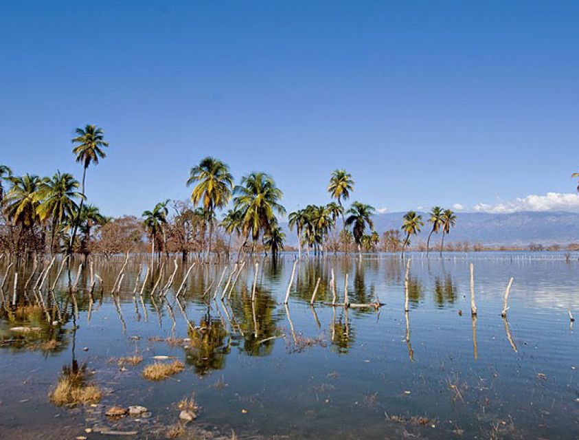
It is the largest natural water reserve in the Dominican Republic, with an area of 375 km² by October 2011, although its area is not constant. Its waters are shared between the provinces of Independencia and Bahoruco. It is part of the Cabritos Island and National Park and the Jaragua-Bahoruco-Enriquillo Biosphere Reserve.